
“We are so small” I said as I looked up at Ngāuruhoe ahead of us, standing between ancient lava flows towering above us on either side. The younger, black, glassy lava flows that were erupted in 1954 are a stark contrast. We kept pushing forward to where we reached large boulders that are scarred and often shattered where they landed. This would have been a deadly place to be during eruptions. I am absolutely in my element here.

Janine Krippner
I am reminded of my Te Awamutu College geography class field trip to the volcanoes all those years ago not too far from where I was now standing. Back then I dreamed of being a volcanologist. As a college student I loved the work so much that I didn’t want the assignment to end; when Mum came home from night duty around 7am I was still up working on it. Now I am doing this for real, figuring out what the rocks can tell us about the volcano and its eruptions.
After the country-wide storm killed our first two days of planned fieldwork, University of Canterbury PhD student Amilea Sork and I spent three long 10 to 12 hour days in the field, hiking up the lower flanks of Ngāuruhoe to better understand the ballistics (flying rocks) of eruptions past. These are historically the deadliest of the eruptive processes within 5km of a crater. They can be ejected during magmatic or phreatic (steam) eruptions. With this cone being so steep, the ballistics don’t just land in place. They roll and bounce out to much greater distances, across the portion of the Tongariro Alpine Crossing track that leads up from the Mangatepopo valley.
We focused on ballistics larger than a metre in diameter, reaching around 5m in length. These sit around 1.5 to 2km from the summit. We are collecting evidence of whether they tumbled off thick lava flows high on the flanks or were blasted up out of the crater. We noted evidence of the rocks being partly fluid or solid when they were erupted, impact marks where they hit the ground or other rocks, and how extensively they fractured with the enormous energies at play. Some of these huge boulders had us perplexed at first, but we methodically pieced together a worthy story as we went over each surface collecting clues. One thing is certain, when Ngauruhoe erupts again you do not want to be where we stood.
We will spend time over the next year at least going over the data we collected, running computer models and analysing satellite data to keep adding to the bigger picture. It is this way that we keep adding to the growing body of knowledge of volcanoes, sometimes feeling painfully slow, making sure we consider all possibilities as we go. The end goal is to understand what areas are impacted by these large ballistics and learn more about how they get there, which can then be applied to other volcanoes around the world.
This is how we figure out these beautiful giants that are such an important part of the planet we live on, and I feel deeply grateful that I get to do this.
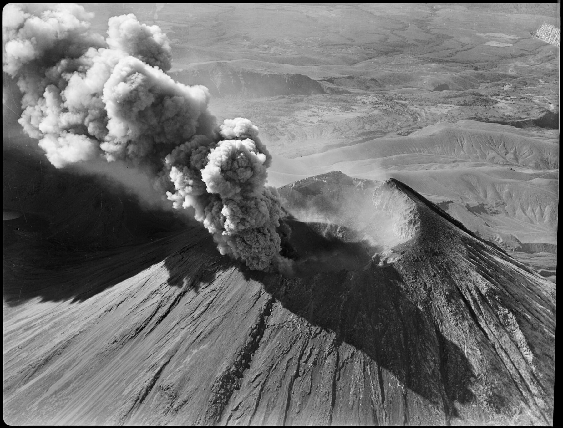
Mt Ngāuruhoe erupting. Photo: National Library.